Six Days of Dogs, Dirt, and
Poor Judgement
Day 1
The trip began around noon on Saturday.
We loaded the bikes on the trailer and headed to Yuma. After parking the
car at the airport around 6 PM, we headed out on the bikes. It was
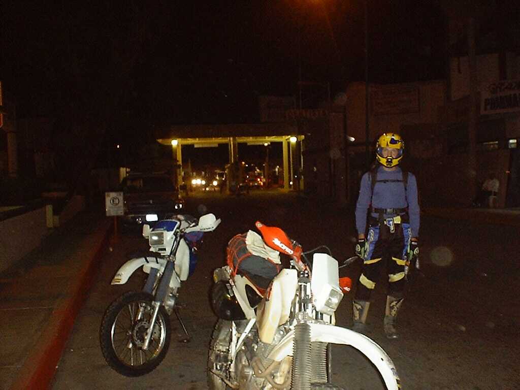
now dark, and after a quick last burger at Burger King, we made our way to
the Algodones border crossing, which closes at 8 PM. We were waived through
the little border crossing and after a quick picture, entered the small community
where everything changed instantly.
We were in Mexico. Our plan according
to the map was to continue directly south to Mex Hwy 2. The problem was,
the road didn't continue anywhere. It just branched off in several directions
as dirt passages through the village. We picked the one that headed in
the most Southerly direction, but it just fizzled off in the village, so
we back-tracked and headed west on what seamed to be the most traveled road.
The Idea was to turn South whenever possible, hoping that we would end up
on Mex 2, which would carry us to our turn at El Condor. After some time
wandering on unmarked roads we ended up on a very soft, sandy road, which
only became softer and sandier. There came a point where the sand was so
deep and soft I had to ride with the throttle pinned to keep moving at good,
yet uncontrollable, pace just to keep from bogging to a stop. To make matters
worse, the lingering clouds of dust and sand made by Dan up ahead left me
in a thick tan cloud, which illuminated by my 80 watt lowbeam, caused a
complete lack of vision for what would be a half hour struggle. We were
in the dunes. We were supposed to be on Mex 2 heading west.
The road finally dumped us out on
pavement, which eventually took us into Mexicali, where we decided to see
if we could find a currency exchange still open. We made our way to
the Calexico crossing soon to discover that the one-way road only crosses
the border and we were on our way back to California. We quickly turned into
a high fenced parking area behind some business to decide what to do. Dan
decided to ride his bike on the sidewalk back to the first street. I watched
as I waited my turn, only to see a police truck light up as Dan turned onto
the street. I quickly backed my bike off of the sidewalk and hid behind the
tall fence. After a short wait I watched the truck pass me by, and made my
dash down the sidewalk. I found Dan waiting one street over. I asked about
his run-in and he said that after he explained his action the officer let
him go. Things were already interesting, and we still haven't found Mex 2!
After more wandering, nothing appeared
to be open, but we found a sign to Tijuana, which is ultimately where Mex
2 ends. Thinking that this would get us to the highway, we set out, realizing
after a while, that this wasn't right. The fields to either side of the
road were burning, (Mexicans seem to like to burn things) which made for
a surreal effect. We pulled over, and as I began to pull out the maps and
the phrase book, Dan disappeared into the adjoining field. I began to ponder
over the maps to see if I recognized our location. A young guy on a bicycle
made his way over to me, introduced himself as "George" and the frustration
of our language barrier began. At first I thought he needed help, but later
I realized that he just wanted to help me. After some laughter and through
some creative signing, rough translations, and map pointing, we arrived
at "that way, left, then right". Dan appeared just in time and we were on
our way.
We found the highway, got gas, and
began our journey west to El Condor. Even in the Dark it was an incredible
drive, as we wound and climbed to an unexpected tollbooth at La Rumerosa.
This presented a new language challenge, as they wanted us to pass between
two bars in the road, or something, and once we figured this out, we were
on our way. When we reached El Condor we somehow found the dirt road heading
south, and followed it until we found a descent place to set up camp. It
was 11 PM and we were at a high elevation, so it was a bit cool, and the
clouds were growing thick and covering the stars. Using my bike's bright
100 watt highbeam, we pitched the tents and turned in. It rained off and
on all night, and I couldn't seem to keep my feet warm.
Day 2
Morning came, and we packed our gear
in the light rain, which turned out to be a difficult task. We headed back
to El Condor to get gas at the Pemex station on the corner, only to discover
in the daylight to be closed down. The next Chance for gas would be Ojos
Negros, which shouldn't be a problem.
The roads passed through beautiful
wine country-like settings and pine forests. Some of the roads had SCORE
arrows marking a previous Baja race course. So far the ride was a blast.
Later that morning we lost our location on the map and decided that we had
taken a wrong turn. As we were pouring over the map at an intersection, we
were met by a military platoon hiking down the crossroad. These machine gun
toting soldiers were loaded to the hilt, and probably not just with gear,
as they each had beer in hand. I eventually picked one to ask for directions
as my very rough Spanish returned to me. "Hola, donde esta el camino a Ojos
Negros?" I asked. He pointed up the road in the direction they were headed.
He then pointed to the rancho "El Coyote" on the map. "El Coyote aqui", he
said. "Aqui" he repeated as he pointed at the ground. Assuming that meant
we were in El Coyote we took off down the road that we understood to lead
to Ojos Negros. This road quickly and seemingly ended at another road, otherwise
continuing as a worn trail. This made no sense, as it wasn't on the map, so
we decided to turn south, figuring that if we could hit Mex 3, we could follow
it into Ojos Negros. After traveling for a while on this high road, we passed
a trail that generally went west, as far as we could tell, from our vantagepoint.
This is the direction we wanted to go, so blindly, off we went. The trail
began to swing back north and east, and after a few trail changes, we found
ourselves on another SCORE course. We figured we couldn't go wrong there,
as eventually the trail had to pop out somewhere important. This trail was
a hoot! As we blasted along this gem of a trail, we came to an intersection.
To our surprise, this was the intersection that we had originally turned
south on; we just popped out on the trail mentioned earlier. This time we
turned north for a while to see where that took us. We came to a fork with
some crude signs on the trees. One said "Rancho San Juan de Dios", the other
"San Faustino". I couldn't find either of these near El Coyote, so I scanned
the rest of the area within 15 miles (more or less), and there they were.
We were a good 15 miles north of El Coyote. If we had just continued south
earlier we would have reached the road to Ojos Negros at El Coyote.
It was after noon now, so we made haste south to our target intersection,
then to Ojos Negros.
The Pemex station in Ojos Negros
was dry, so we decided to stretch our tanks to Ensenada via Mex 3. The
30 mile route to Ensenada is a beautiful ride, and the pavement quality
is surprisingly excellent. As we descended into town we stopped to gas-up.
I filled my tank, and having not changed currency, paid in dollars. The
attendant gave me the "more or less" hand twist and said "ten dollars".
I new I was getting ripped off, but I had cars behind me, so I paid. From
here on I would have my calculator out for every dollar transaction. We
continued into town, which is big and busy. Being Sunday, the banks were
closed, so we rested for a little while, went down to the beach, then decided
to check out La Bufadora for dinner.
La Bufadora, meaning "The Blowhole"
is a bluff on a peninsula west of Maneadero where the shape of the land
causes water to shoot up to 100 feet into the air. There are a few restaurants
and a nice little shopping area. I explored the shopping strip on the bike,
and was attacked by two bloodthirsty dogs who obviously don't like motorcycles
(we later concluded that no dogs in Baja like motorcycles, and there are
MANY dogs). I started popping wheelies and revving, and they eventually
left me alone. Why was everyone staring at me? We ate at a clean little
restaurant named "Celia's", and I had lobster burritos. WOW.
It was getting dark and we didn't have time to head south looking for a place to camp on the beach (this area is too rocky). The waiter/owner suggested that we go down the hill to a small, private campground. It's $5 per night, on the water and convenient, so we checked it out. when we arrived, we were greeted by a sign that said "no motorcycles". We couldn't find the owner, so we stood around until a kid showed up in a white VW. He asked if he could help us, we told him we wanted to camp, and he said "sure, the bathrooms are over there, the water should be on" and drove off. Okay... We set up camp and sat up around the fire for a while. I tried to call my wife on the cell phone, but even though I had a full signal, it wouldn't let me through (I thought AT&T was international), then went to bed. It rained a little that night, and my feet got cold...

Day 3
I awoke the next morning to hear
some little kid fussing at Dan about private property, but when I came out,
he was gone. It didn't really matter because we were leaving anyway. It was
cool, overcast and humid, with a little drizzle here and there. We checked
out a bluff, then headed out.
In Maneadero we got pesos at a bank,
got gas, and I called my wife while Dan got breakfast at a little hole
in the wall (literally!). Once Dan finished his dog taco, we were on our
way. At Santo Tomas we turned southwest on this year's Baja 1000 course,
followed it to the coast, and along the coast (more incredible scenery)
to Erendira, where we were attacked by hordes of obnoxious children begging
for stickers. Dan gave them each a piece of candy, each of them take one
and put out their other hand. They were grabbing at and climbing on the
bikes; I saw one grab Dan's header pipe, I cringed but it didn't seem to
phase him. The longer we sat there the more kids appeared, so we straddled
our steeds and headed for the hills. There was a little confusion on where
the trail picked up, but we found it again, passing a fenced schoolyard
with about 20 little bodies plastered against the chain link fence. We
popped wheelies as we roared on.
Back on the Baja 1000 course, we continued
to follow the coast on some fun roads, I had a good wipe out, then we headed
inland to Punta Colonet for gas. Colonet was out of gas, so we hit another
dirt road that we thought was the road to the inside of Bahia Colonet.
It wasn't, and we wandered everywhere looking for a way to get there. This
was the day of dead ends. We finally ended up back on the road we started
on, backtracked a little, then turned south on a trail that got us to the
bay. The sun was begining to set, and I wanted to photograph the beached
ship at Punta San Jacinto. These roads/trails were smooth and offered great
traction; we made good time. We reach the ship, which is deteriorating quickly,
and I shot what I could, although the light was poor.
We re-entered the highway at Camalu
and as the sun fell, we continue on the highway for San Quintin. My bike
started missing and jerking, so I switch to reserve, eventhough I shouldn't
have to. It continued to do so. We stopped at a Pemex in Vicente Guerrero,
filled-up, and my bike began dying when I put it in gear. The culprit was
the kickstand switch, which I have intended to bypass since I got the bike,
so I did. These switches are such a nuisance.
We arrived in San Quintin, where we
had decided to get a hotel, which would probably be on the bay for the
good ones. So we took off into the dark back roads looking for it. Dan
asked a local where the hotels are, and he said to go down to first stop,
and take a right (loosely translated). We never found the stop, but we found
signs to a couple of hotels. When we reached the hotels, we consulted a
book to see if either was in it. "The Old Mill" was, and was a "must stop".
So we did.
We parked the bikes at the office and were greeted by a friendly American female voice; "you're late!" she said. She handed us each a cold cervesa, we chatted a while, then her white-bearded husband (or Santa Clause), came around and was just as friendly. They are the owners, Jim and Nancy, and are from San Diego. They are great natured people with loads of character, retired at 50, moved down in '95 to buy the old grain mill and cannery and turned the workers quarters into a hotel. The quarters were built in the 1930's, and aren't fancy, but they are clean and unique. The place has a wonderful atmosphere, with landscaping, a covered sitting area with a fireplace, and a restaurant (closed when we arrived). Jim told us to go get cleaned up, and he'll give us the truck to take into town to get a bite to eat! We couldn't believe it, so we did, and he made some suggestions on restaurants. We came back and hit the sack. No cold feet tonight.
Day 4
We got up Tuesday morning, took
some pictures, talked to some visitors, tipped generously, and hit the road.
Seeing how so many of the Pemex stations don't have gas, we decided to stick
to the pavement for this leg of the trip, other than a few off-road side
trips, as the deeper into the peninsula you go, the villages get fewer and
farther between.
We stopped for gas and breakfast in
El Rosario, then continued on to what was expected to be an easy trip to
Chapala and a short journey up to the Sea of Cortes. We planned two "short"
side trips, one to "El Marmol", an abandoned onyx mine and camp roughly
15 miles east of the highway at Sonora. The attraction there is a schoolhouse
made of onyx, the only one of it's kind in the world, a graveyard, as well
as the typical abandoned mine setting. The other side trip would be to
Mision Santa Maria.
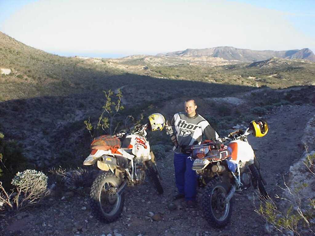
It was a nice, scenic, mountain ride
on Mex 1 to the El Marmol road, a lackluster ride to the mine, where we
rested and took pictures, back to the highway, then an incredibly scenic
ride to Catavina. These last 20 miles wound through Sonoran desert that
rivaled that in Arizona 10 fold, covered with huge white boulders, and very
dense with Cardon cacti and "boojum" plants. Boojums can't be described,
one just needs to see them to understand; peculiar and amusing are all that
come to mind.
Catavina is a couple of tiny stores,
a huge hotel, and a once grand, but now abandoned Pemex station with a
man selling gas from 5 gallon cans out of his pick-up in the parking lot.
This would be the last chance for gas until at least Puertocitos, back
up the gulf side. As we were filling up I asked the man if there was a way
to pass from the road to the Mision Santa Maria to the gulf coast road,
he said he didn't think so.
We found the trail to the mission,
which was long and treacherous, but quite a hoot at times, to a high point
where we could see the gulf (Sea of Cortes). The trail seemed as though
it would continue to the gulf. Even though the trail was getting progressively
worse, it all seemed to be down hill, and in our excitement for our newfound
pass, we pressed on. It had been over 10 miles, and no sign of the mission,
but at this point we didn't care, because we had found our "short cut".
Ah, ignorance. The trail turned south after a couple of miles, and got worse
and worse. But it was downhill, and the map showed that it looped back to
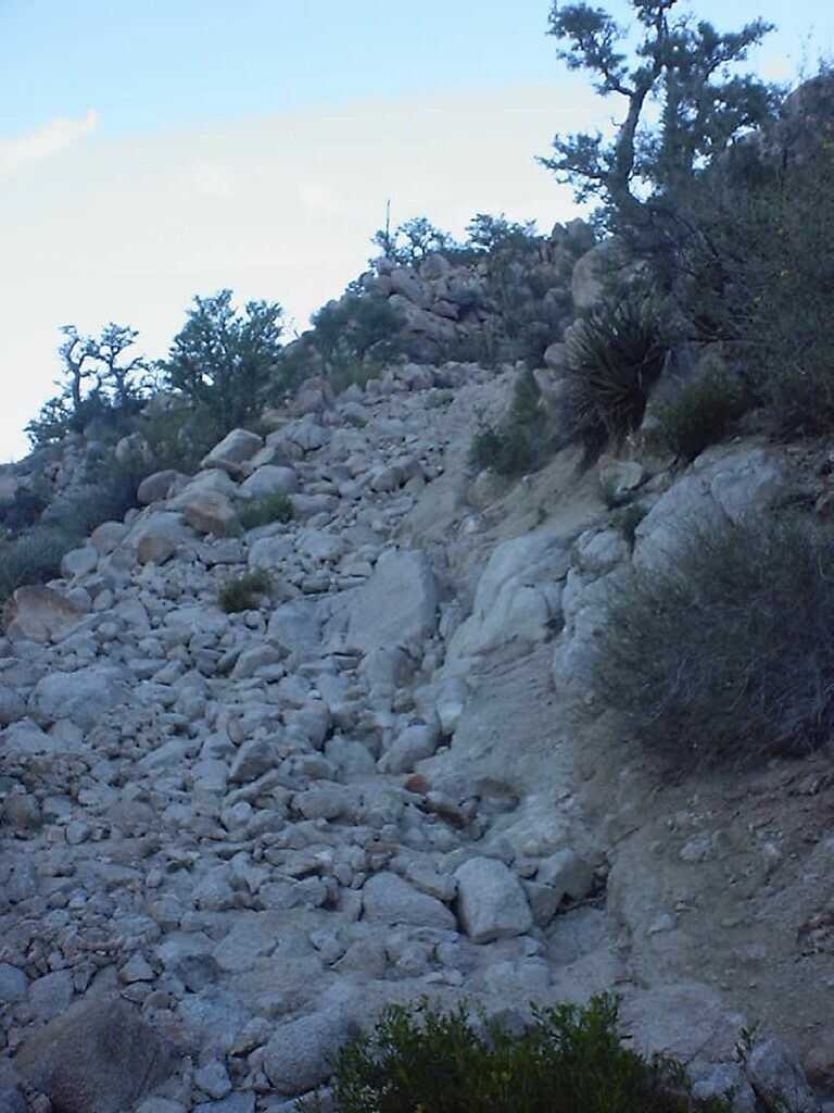
the highway at worst, if our "pass" did not work out. We came to a long,
very steep, winding descent made up of 12"+ boulders, but hey, it wasn't
like we would have to return this way, so we slowly made our way down. At
the bottom we reveled in our accomplishment, and moved on. We then arrived
at a sandy swamp, full of tall grass and palm trees, which the trail continued
through for about 100 feet. The water was dark; depth unknown, but we couldn't
go back up the way we came, so Dan tried to ride around the obstacle. The
sand was deep, and difficult to cross, but the place where he crossed through
the water was only about 18" deep. The bottom seemed firm, so we decided
that it would be easier for me to negotiate the water. I hiked back to my
bike, and attempted to ride it up the short hill for a running start. I
found myself stuck in a rut; the rear wheel dug in too deep for me to rock
it out, so I had to lift it. Once out of the rut and up the hill, I made
my way down and plunged into the dark water. I instantly found myself up
to the gas tank in water, so I immediately grabbed a hand-full of throttle
and held on tight as the big single sang it's way through the sandy bog.
As I popped out at the end I shut it down, resting in relief that it didn't
stall in 3 feet of water.
It was getting late, I was soaked, and the worst was behind us. As the trail continued south along a wash, we both noticed some formations up the hill. We realized it was the mission, and went to check it out. Considering that the structure was built in 1767 out of adobe and abandoned after only 3 years, and has been through countless harsh seasons and hurricanes, quite a bit remains. The main trail seemed to end here, and a faint trail seemed to follow the wash, in the wrong direction. The sun was setting, and we were trapped; no getting to the gulf or the highway tonight. We pitched our tents in the mission and started a campfire off to the side, where we pondered over the topos and explored trail and navigational theories, trying not to realize that we might be in trouble. The Best thing to do was try to get a good night's sleep; we would need it tomorrow. I left my boots on.
Day 5
Wednesday morning Dan and I both got
up before dawn, and began packing in the moonlight. As I loaded the gear on
my bike, I noticed the fender felt springy. Upon further investigation, I
discovered that my subframe had broken on the right side at the fender, just
below the seat. The left side was all that was holding on, including the
weight of my gear, not a good situation. To top it off, Dan and I discovered
that we were both almost out of water.
As day broke, Dan went to explore the
wash, and I hiked up the hill to see if I could see where the trail picked
up, or an alternate route, or anything else, for that matter. I became very
excited as I came out on a trail, which I followed for some distance before
I spotted something black in the path; it was a glove, my glove. I had
taken them off and tucked them away after coming out of the water, as they
were soaked. In disbelief, I returned to the camp to wait for Dan.
He returned and said that the wash
ended in impossible terrain. It
was approaching 8 AM, and we had
no choice but to go back the way we came.
Despite a sandy launch pad, the swamp
turned out to be no more of a challenge than the first time through. We
arrive at the steep, boulder-strewn descent, which is now a climb. We decided
to take my bike up first, as it was a little heavier. After about half an
hour of pushing, pulling, lifting, and clutch-work under power, we eventually
reached the top with the 300 pound machine and rested for a while. We did
the impossible. The air was cool, yet the sun was unforgiving, and we were
out of water. After the struggle with my bike, we learned what
works and what doesn't, so Dan's went up a bit easier.
The worst obstacle was behind us,
but we still had about 15 miles of misery ahead of us. I focused on grace,
keeping it as smooth as possible for my frame's sake, and luckily had little
struggle. We finally reached the highway and returned to Catavina for gas,
water and a well-deserved coke. I read after our return home that this mission
is nicknamed "Mission Impossible". Very fitting. When we returned for gas,
I told the old man, "el camino a Mision Santa Maria no paso, no-pa-so!" We
chuckled and pressed on.
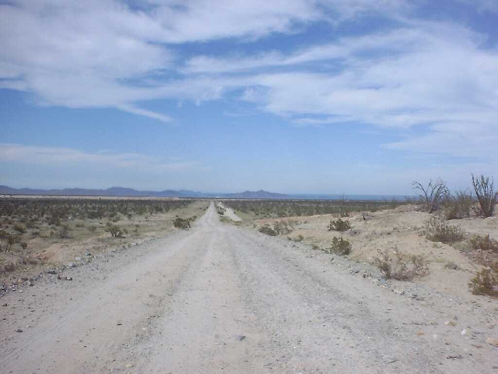
We finally reached the road that would
take us to San Felipe, and began our trek north. This was a big, open dirt
road, made with the worst rock possible and plagued by the worst washboard
I have ever seen. It is over 100 miles of misery. It's pretty bad when
a constructed and maintained road is so much worse than the crude off-road
trails we had ridden the majority of the last 900 miles on. The road is so
bad, that local traffic drives off of the road on either side when possible,
making very smooth and entertaining paths. The scenery is incredible and
ever changing, and the gulf is deep blue and as smooth as glass, with mountain
islands breaking the surface here and there. The washboard seemed to get
worse and worse, at times bringing us to a slow crawl. I kept having to pullover
and re-attach my front fender bag, which would vibrate loose no matter how
hard I pulled the straps. Just about the time we though the road would never
end, it didn't. After hours of this hammering, we were teased by short distances
of pavement in Puertocitos. The two Pemex stations here were closed. Not
far from this point however, we did reach pavement, and as the sun set,
we sped toward San Felipe. After filling-up at the first Pemex we came to,
I called my wife, and we made our way into town.
We headed for the water where the hotels would be, and stopped at the first neon-signed hotel and restaurant we came to. It had banners advertising "2 adults $24.95, mon.-thurs." After inquiring within, we discovered that this was one bed, so we bumped up to the $35 room. Since the restaurant is very nice, we went with it. We should have asked to see the rooms first. Ours was a total dump. You'd probably pay $10 for something like that in the states. But, we were tired and hungry, so we unloaded our gear in the room and seated ourselves on the patio at the restaurant. Excellent. I had some of the best chicken fajitas I had ever tasted. We returned to the room and showered, I laid out my sleeping bag on the bed, threw a shirt over the pillow, watched some HBO, and passed out.
Day 6
We awoke Thursday morning, packed
up and moved out. We decided to have breakfast at a second floor corner
coffee shop. It appeared to be American owned, as it advertised deli sandwiches,
bagels, smoothies and so on, and there was much more pride in presentation
than typical Mexican eateries. We went up and sat on the balcony overlooking
the town, and ordered. I had a wonderful omelet, with homemade bread and
seasoned fries.
San Felipe is a nice little fishing
town that appeared to be much cleaner than the others we visited. We went
down to see the fishing boats, and take pictures of the big boats stuck
on dry land. Yes, that's right, this area supposedly sees 20 foot tides,
some times leaving boats on their sides in the sand.
After amusing ourselves, we made a
run for the border, which would be a quick 2 hours of pavement, then hit
I-8 back to Yuma. I should know by now that things are never this simple,
its Casey's law. About an hour into our ride, I noticed that the back of
my bike seemed to be wandering, so I pulled off of the highway, to find my
rear tire flatter'n a pancake. I moved under a shade tree, set the bike up
on an old igloo cooler that Dan found, and went to work. An old patch apparently
couldn't handle the highway heat. I inserted the spare tube, put everything
back together, and aired-up. It didn't hold. After pulling the tube back
out, I discovered two new pinch marks in the tube at the valve stem. I couldn't
believe it, I never pinch tubes! I tried to patch it, but being on the inside
and near the stem it didn't hold, so I took Dan's spare. Dad-gum if I didn't
pinch it too! In disbelief, I tried to patch his well-used spare, but the
glue didn't want to stick. I put it together anyway and took off, having
to stop and pump the tire every few miles. At one stop, Dan said that he
had seen a motorcycle/ lawnmower repair shop about a mile back. As he went
back to see if they had a tube, I pushed the bike into an abandoned Pemex
service station, and lifted it up onto a crate I found. Dan returned with
a box of patches, as they didn't have any tubes. I figured this was worth
a try, so I went to work. This glue didn't seem to want to hold either, but
the patches were bigger, so I hoped that this would at least buy me some
more riding time.
Well, It got us to the border, in
rush hour traffic. I'd never sat in a line this long and slow before. After
walking the bikes for half an hour, we decided to take the advice of those
around us, and lane split to the front. Several people around us insisted
that it was legal. It worked, and no one opened their doors on us. At the
crossing, we answered a bunch of dumb questions, a guy knocked on my gas
tank, and we were on our way.
On the freeway, about 45 miles from our destination, my bike started missing and sputtering, so even though the trip meter only read 157 miles, I switched to reserve. This solved the problem, but meant that I was either getting horrible gas mileage, or someone borrowed some gas. Bad mileage wasn't likely, as this tank was mostly highway between 50-60 MPH, and I had gotten 60 miles per gallon earlier in similar circumstances. About 20 miles outside of Yuma, It happened again. I was out of gas. Then I remembered the third-full 1-gallon can that I had carried on my rear fender for the past 1100 miles. Figures, huh? That got us to the next station. We arrived at the car in Yuma at around 6 PM, unpacked the bikes, and loaded them onto the trailer.